The Problem – Existing Utilities
The identification and adjustment of existing utilities is a key component to every roadway project, from major highway expansions to subdivision street reconstruction. Existing underground utilities are prevalent in our public right-of-way. These utilities are owned by various companies, installed at various depths, made of different materials, and vary in size and complexity. This is a major project risk, and lack of attention to these utilities within the limits of your roadway project can be detrimental to the project schedule and budget.
Utility owners are notorious for having poor record maps, no as-built information, and poor responsiveness to data requests. A roadway engineer that uses this substandard information coupled with 811 “One Call” tickets when completing a conflict analysis will make important design decisions based on unreliable utility information. In roadway design, decisions on critical items such as a bridge drill shaft location or storm drain flow line can be very difficult to change if a utility conflict is identified late in the design process.
Utility relocations can also be a major cost and schedule concern on a roadway project. Relocating a high-pressure pipeline or a major telecommunications duct bank is by no means a fun or cheap experience. Failing to plan appropriately for major utility accommodations or relocations could cause potential risks for project delays and contractor claims to go up exponentially.
The Solution – Subsurface Utility Engineering
Subsurface Utility Engineering (SUE) is a proven solution to identifying existing subsurface utilities on roadway projects. By identifying existing utility conflicts early in the design life of a project, the engineer may be able to mitigate or eliminate utility impacts. The use of SUE has been endorsed by numerous industry organizations, including the Federal Highway Administration (FHWA), the American Association of State Highway and Transportation Officials (AASHTO), and the American Society of Civil Engineers (ASCE). The ASCE standard that defines SUE practices, CI/ASCE 38-02 “Standard Guidelines for the Collection and Depiction of Existing Subsurface Utility Data”, has become the industry standard for transportation engineers around the country.
SUE has become a routine requirement on highway projects for numerous State departments of transportation, including the Texas DOT, Florida DOT, Virginia DOT, Pennsylvania DOT and many others. It is important that the roadway design engineer become familiar with the ASCE standard and the SUE quality levels, so he/she can walk into a project scoping meeting with the client and correctly recommend the need for SUE and the level of the investigation needed.
Applying SUE on Highway/Roadway Projects
Quality Level D (QL “D”) SUE investigation is completed by performing thorough records research and obtaining all existing utility records and as-builts available for the limits of the roadway project. QL “D” SUE is the lowest level of accuracy and is recommended for use during the planning or schematic design phase of the roadway project, but is not recommended for use during detailed PS&E design.
Quality Level C (QL “C”) SUE investigation incorporates surveyed above-ground utility features from topographic survey and reconciles it with QL “D” record information. This level of accuracy is recommended for rural, FM roadway projects with low utility congestion, few utility crossings, and few roadway intersections. The roadway design engineer may even review the QL “C” data and request further investigation in specific areas, such as intersections or areas of drainage improvements.
Quality Level B (QL “B”) SUE investigation is completed by performing a surface geophysical investigation, also known as “designating”, and providing two-dimensional horizontal information for existing utilities. This level of accuracy is recommended for more complex roadway projects in urban and suburban environments, where utility congestion is high, along with the potential risk of utility conflicts. The finished QL “B” product is a 2D file in Microstation or AutoCAD format, with existing utilities owners and types identified by specific level, color and linestyle. The engineer is then able to reference utility data into working roadway design files and an accurate conflict analysis can be completed.
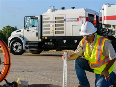
Quality Level A (QL “A”) SUE test holes are completed using non-destructive vacuum excavation equipment and provide highly accurate three-dimensional horizontal and vertical information. It is recommended that the test holes be performed at precise utility conflict locations, based on a detailed conflict analysis with roadway improvements. QL “A” should be completed by 60% roadway design so that the utility elevation data can be used to make design decisions with roadway and drainage profiles.
Keep an eye on this blog for updates. This is the second in an 8-part series on SUE, in which we will touch on the importance of SUE in several different markets, including rail, water & wastewater, campuses and facilities design, and more. In the meantime, let us know if you and your team are interested in a more in-depth “Lunch & Learn” on SUE. You may contact us at pburnett@rios-group.com / 817-345-7500 or tisaacson@rios-group.com/ 512-580-5440.